Google Sinks Atlantis Discovery Buzz
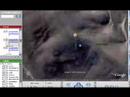
Last week, a British man announced he'd found the lost city of Atlantis using Google Ocean-the latest add-on to Google Earth that features 3D bathymetry, which lets you explore the ocean floor. The supposed ‘Atlantis' image is about 620 miles off the northwestern coast of Africa and south of Portugal. It shows a rectangular grid with what looks like roadways leading away from it at the coordinates 31 15'15.53N 24 15'30.53W. According to The Telegraph, the newspaper that first reported the "discovery," the pattern is roughly the size of Wales (around 8,000 sq. mi.).
Friday's find sparked intense interest online despite the farfetched claim. Many scratched their heads wondering, what if? After all, this underwater discovery seemed to match the location Plato had described in his writings. Plato said Atlantis was a massive island that was "larger than Libya and Asia together," and located at a "distant point in the Atlantic Ocean...in front of the mouth of the pillars of Hercules" (the Straits of Gibraltar).


 :
: